
Last updated: November 13, 2026
If you saw this week’s headline that Korea finally cleared Google Maps, you might be wondering whether the blue walking line will work when you land at Incheon. Not yet. After a dispute that started in 2007, Google Maps in Korea still shows places and transit routes, but no walking or driving directions, and Google hasn’t announced a launch date.
Here is what did happen on November 13, 2026: a Korean government council confirmed that Google met the security conditions attached to its map data approval. That is a real milestone. It is also a step before a launch, not the launch itself.
Ask almost any Korean what map app they use and you’ll hear Naver or Kakao, not Google. That’s the part that matters for your trip. This guide explains why Google Maps was limited, what changed this week, what to use in the meantime, and why I’d still set up Naver Map even if Google’s directions arrive.
Quick Answer: Does Google Maps Work in South Korea Right Now?
- Partly. Google Maps in Korea works for searching places, viewing photos and reviews, and getting public transit directions. It does not give turn-by-turn walking or driving directions.
- What changed on Nov 13: The council that reviews map exports confirmed Google had met its security conditions. Google said it looks forward to launching Google Maps in Korea.
- When will directions arrive? No launch date has been announced. Korean press reports that the government expects the actual data export to begin in the first quarter of 2027, and industry sources say Google is aiming for navigation around then. Google hasn’t confirmed that.
- What to use now: Naver Map as your main map, Kakao Map as a backup. Keep Google Maps for saved lists and English reviews.
- How to plan: Build your trip as if Google’s directions won’t be there. If they show up before you fly, treat it as a bonus.
Why Google Maps Has Been Limited in Korea (Plain English)
Korea restricts taking its detailed government survey maps out of the country. The scale in question is 1:5,000, detailed enough to show individual roads and buildings. The stated reason is national security: Korea and North Korea are still technically at war under a 1953 armistice, and the government has worried about exposing military and other sensitive sites.
Google builds its walking and driving routes in data centers around the world. To do that in Korea, it needed that detailed data on servers outside the country. Korea turned down Google’s requests in 2007 and 2016. Naver, Kakao, and TMAP run on servers inside Korea, so they never had that problem.
Think of it like opening Google Maps in New York and finding that you can see every pizza place but can’t get directions to any of them. That’s roughly what visitors have seen in Korea, and why Seoul’s walking legs in a transit route often show up as a dotted line instead of a real path.
It also explains why Google Maps in Korea is a minority choice. In Mobile Index figures reported by Hankyung for October, Naver Map had about 31.2 million monthly active users and Google Maps 10.5 million, with TMAP and Kakao Map in between.
What Happened on November 13, 2026
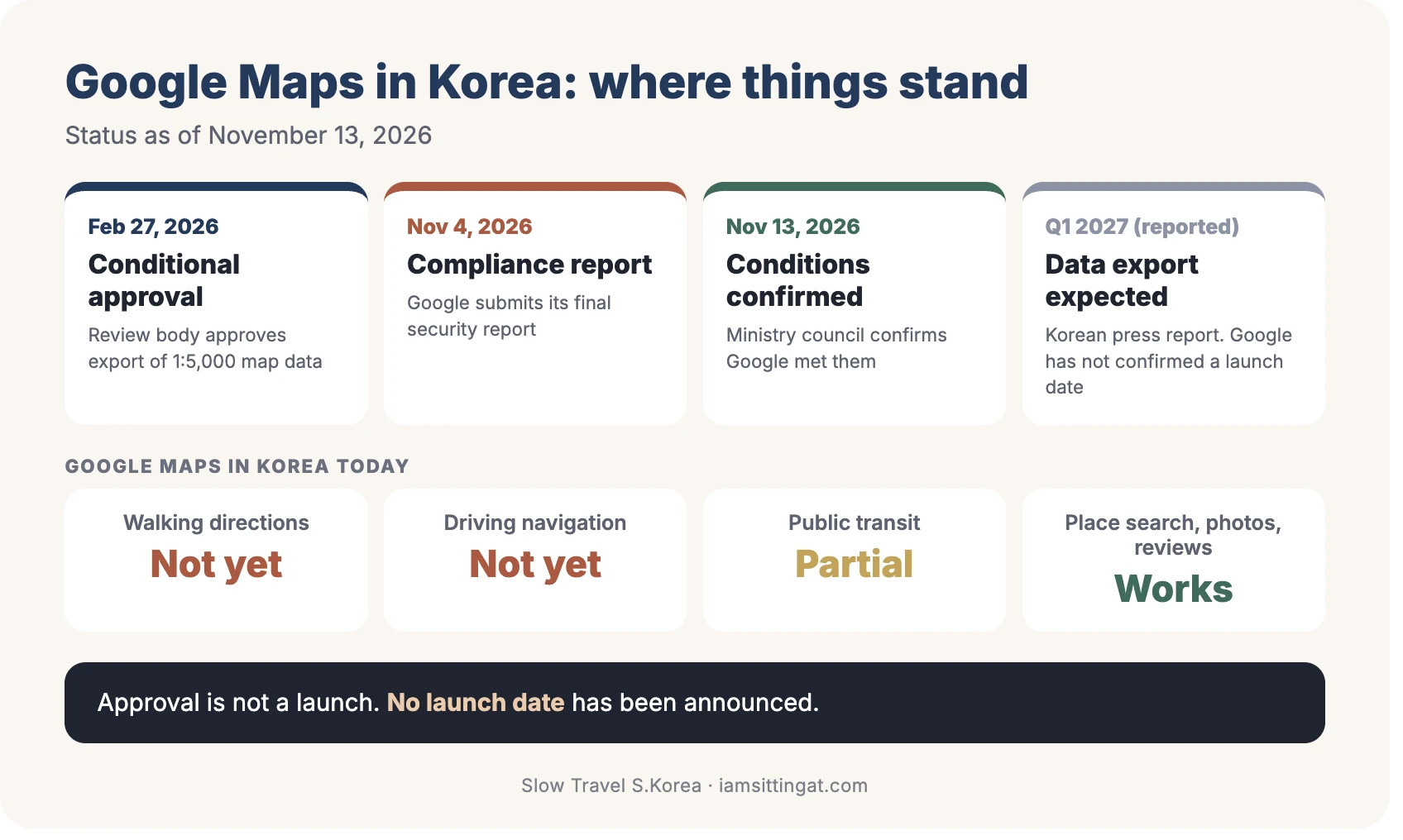
Here is the timeline, with the parts that are confirmed and the parts that are still reported:
- 2007 and 2016: Google’s earlier export requests are rejected.
- February 2025: Google files its latest request.
- February 27, 2026: A Korean interagency review body conditionally approves export of 1:5,000-scale map data to Google, ending a dispute of nearly 20 years.
- November 4, 2026: Google submits its final security-compliance report.
- November 13, 2026: The council reviews the report and confirms Google met the conditions, according to ZDNet Korea and Hankyung. Google said in a statement that it looks forward to launching Google Maps in Korea.
- Q1 2027 (reported): Hankyung reports that the Ministry of Land, Infrastructure and Transport expects the actual export of map data to start in the first quarter of next year. ZDNet Korea’s report of the same meeting doesn’t give a start date.
What Google had to agree to
The conditions are mostly about security. In plain English:
- Korean coordinates are removed or restricted. Latitude and longitude for Korean territory are no longer displayed in Google Maps and Google Earth, and the council confirmed this was done.
- A Korean partner handles the data. Google has a deal with TMAP Mobility, which processes the data on servers in Korea and passes Google only the base map and road network: road names, lane counts, speed limits, and road geometry.
- Imagery gets swapped. Satellite and aerial photos processed by Korea’s National Geographic Information Institute will be supplied through the partner and replace the overseas imagery now in use. Street View near military and security facilities is being removed or expanded.
- A named person is responsible. Google Korea’s president is the designated officer for Korean maps, with a 24-hour response team and a one-business-day deadline to fix security issues the government flags.
- The permit can be pulled. The government can suspend or revoke the permission for serious violations, and Google agreed to a technical measure that can disable specific functions in an emergency.
Two things you might notice: satellite views of Korea may look different once the new imagery is loaded, and dropping a pin may no longer show coordinates for a Korean location.
Google Maps in Korea: What Works Today vs. What’s Expected After Launch
| Feature | Today (as of Nov 13, 2026) | Expected after launch |
|---|---|---|
| Place search, photos, reviews | Works | Korean press expects Google to expand into restaurant and hotel search; nothing announced for visitors |
| Public transit directions | Works, but walking parts are dotted lines and details are thin | Likely to improve once road data arrives |
| Walking directions | No turn-by-turn guidance | Expected, but no date and no feature details announced |
| Driving navigation | Not available | Google has said turn-by-turn navigation is the plan; no date announced |
| Satellite imagery and Street View | Overseas imagery, partial masking of some facilities | Government-processed imagery replaces it; Street View removed near security sites |
| Coordinates for Korean locations | Display removed or restricted | Stays restricted under the conditions |
| Launch date | None announced | Reports point to Q1 2027 for data export; Google hasn’t confirmed a launch date |
When Will Google Maps Directions Launch in Korea? What We Know and Don’t
Confirmed: The council signed off on Google’s security compliance. Google said it looks forward to launching. TMAP Mobility is the data partner.
Reported but not confirmed by Google: The government expects data export to begin in Q1 2027, and industry sources told the Korea Herald that Google is targeting a Q1 2027 launch of its navigation service.
Not known: the exact launch date, whether walking, driving, and transit improvements arrive together, and whether Google will roll out city by city.
If your trip is before spring 2027, plan around Naver Map. If it’s after, check Google’s walking directions on your first day, and keep Naver Map ready either way.
What to Use in Korea Right Now: Naver Map vs. Kakao Map vs. Google Maps
| Naver Map | Kakao Map | Google Maps (Nov 2026) | |
|---|---|---|---|
| English interface | Yes (also Chinese and Japanese) | Yes, but less complete than Naver per several guides | Yes |
| Walking directions | Yes; live voice guidance on Android, iOS planned | Yes | No turn-by-turn |
| Subway and bus directions | Yes, with live arrivals and exit numbers | Yes, with live bus and train positions | Yes, thinner detail |
| Driving navigation | Yes | Yes | Not available |
| Place info and reviews | Most complete; reviews machine-translated | Strong | Search, photos, and reviews work |
| Book a table or class | Yes, with passport verification | Limited | No |
| Best use for visitors | Main map | Backup, taxis (via Kakao T) | Saved lists, English reviews |
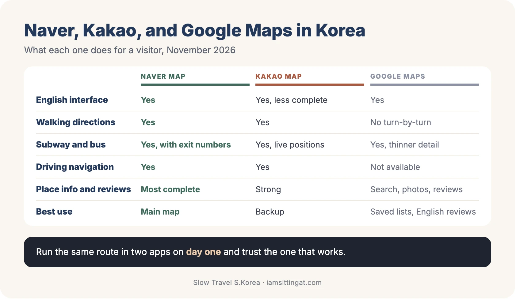
Naver Map is the one I’d put on your home screen. It has the most complete English version and the deepest place data, and its subway directions tell you which exit to use. The downsides: it uses a lot of battery and data, and small places often need a Korean name to show up in search.
Kakao Map is a better backup than most people expect. Directions are solid and live bus and train positions are handy, but English is thinner than Naver’s. For cabs, my Kakao T guide covers that app.
Google Maps is still useful, just not for getting there. Keep it for saved lists and English reviews.
For the rest of the essentials, see my older roundup, Korea Travel Apps for Foreigners.
How to Set Up Naver Map in English (5 Minutes)
Do this at home on Wi-Fi, before your flight.
- Download NAVER Map from the App Store or Google Play. The developer is NAVER Corp. You don’t need an account for search and directions.
- Switch the language. On Android, open the menu, then Settings, then Language, and choose English. On iPhone, tap MY, then Settings, then Language, or go to your iPhone’s Settings, find NAVER Map, and set Preferred Language to English.
- Allow location “While Using the App.” Without it, you won’t see your position or get walking guidance.
- Save your hotel’s Korean name and address somewhere you can copy and paste.
- Paste Korean names for small places. English search works for big landmarks and stations. For a neighborhood cafe, copy the Korean name from the post or booking page.
The full walkthrough, including how to read subway directions, is in How to Use Naver Map in English. If you’ll rely on maps underground, line up mobile data first: [AFFILIATE: Korea eSIM] Best eSIM for Korea.
Why Naver Map Will Probably Stay Useful Even After Google Launches
I can’t predict how good Google’s launch will be. But there are a few reasons I’d still keep Naver Map on my phone, and these are my expectations, not guarantees:
- Korean place names. Small cafes, bakeries, and restaurants are listed in Korean first. A new Google data feed gives Google roads and base maps. It doesn’t automatically bring years of Korean listings.
- Reviews from locals. Naver is where many Koreans leave reviews and make reservations. Naver has translated reviews into English since 2024, and since June 4, 2026, foreign visitors can verify with a passport to book in the app.
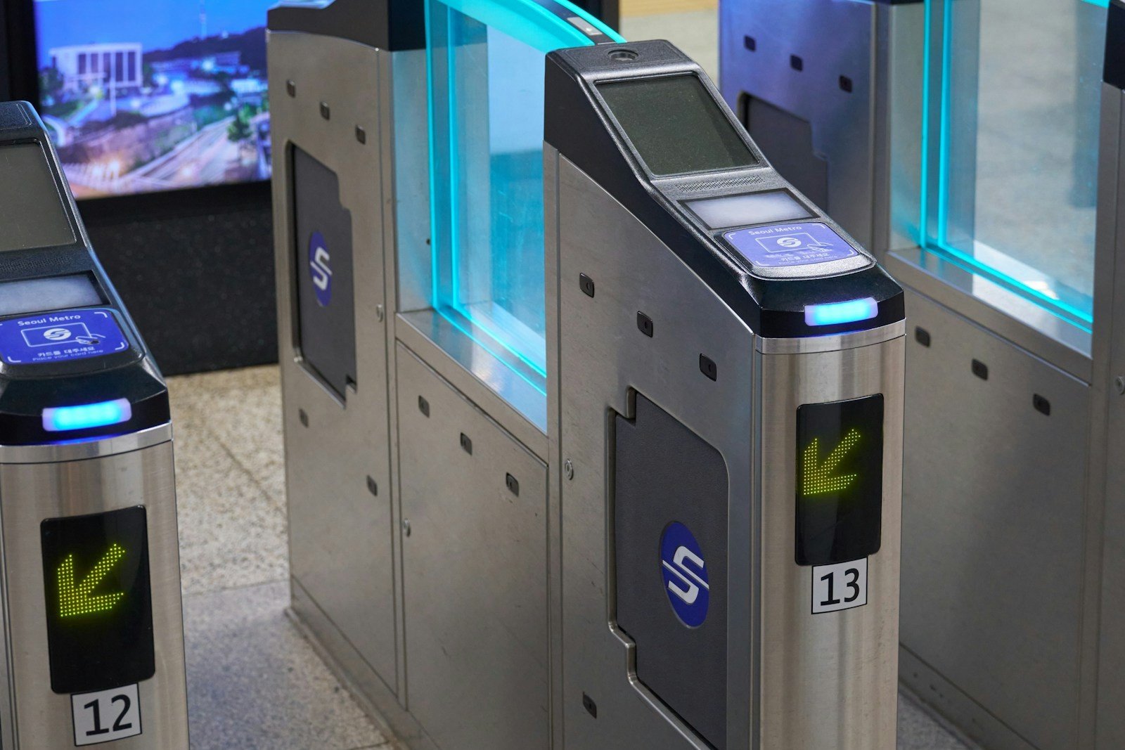
- Subway exit numbers. Seoul stations can have a dozen exits, and the right number saves a long walk. Naver shows the exit closest to your destination. I’d want to see Google do the same before I trusted it. Seoul subway guide for tourists explains how exits work, and my Seoul subway vs NYC subway comparison compares it with what you know from New York.
- Habit and scale. Naver Map has roughly three times Google’s monthly users in Korea, and local businesses keep their details current where their customers are.
Google may become the better choice for some people. The simple test: run the same route in both apps on your first day and see which one you trust.

Your Checklist: What to Do Before and During Your Trip
Before you fly
- ☐ Download and set up Naver Map in English
- ☐ Download Kakao Map as a backup
- ☐ Update Google Maps and keep your saved lists
- ☐ Save your hotel’s Korean name and address
- ☐ Copy the Korean names of cafes and restaurants you want to visit
- ☐ Sort out mobile data: [AFFILIATE: Korea eSIM] Best eSIM for Korea
- ☐ Get a transit card plan: T-money Card Guide
- ☐ Check Google’s announcements for a Korea launch date
When you land
- ☐ Try the same walking route in Google Maps and Naver Map once
- ☐ If Google gives a real route line with voice guidance, great. If it shows a dotted line, switch to Naver
- ☐ Use Naver’s exit numbers before you come up from the platform
For walking-heavy days
- ☐ Routes with many short stops, like KPop Demon Hunters Seoul Locations Route, are where Naver’s walking directions earn their keep
- ☐ For slower days, see Quiet Neighborhoods in Seoul
Reality Check
- Approval isn’t launch. Nothing announced on November 13 is a launch date for walking or driving directions.
- Reports on timing differ. One report says export starts in Q1 2027, while another report of the same meeting gave no date. Treat Q1 2027 as likely, not firm.
- The first version may be rough. This is my expectation: Google still has to load Korean road data and keep it updated under Korean rules.
- Features could change. The government can suspend or revoke the permit or switch off functions in an emergency.
- Your saved lists don’t transfer. If you use Naver, you’ll re-save places or keep Google open for the list.
- Battery and data. Navigation apps drain both. Carry a small power bank.
- I’m not affiliated with Google, Naver, Kakao, or the Korean government. This guide is based on news reports and public information as of November 13, 2026.
FAQ
Does Google Maps work in South Korea as of November 2026?
Partly. You can search for places, see photos and reviews, and get public transit directions. Turn-by-turn walking and driving directions are not available. Korea’s approval and Google’s compliance are done, but I found no report that the directions have launched.
Did Google launch walking and driving directions in Korea, and when will they start?
Not as far as I could verify, and no launch date has been announced. Korean press reports that the government expects the map data export to begin in the first quarter of 2027, and industry sources say Google is aiming for around then. Google hasn’t confirmed it.
Should I still download Naver Map for my Korea trip?
Yes. It gives walking, subway, bus, and driving directions in English, shows subway exit numbers, and has the most place information. Even if Google’s directions arrive, Naver is the map most locals use, so it’s a good second opinion.
The Bottom Line
The news this week is real: Korea’s long standoff over Google Maps is ending, and directions are likely coming. But Google Maps in Korea today is still a place-search and transit tool, not a way to get from your hotel to a cafe. Set up Naver Map in English before you fly, keep Kakao Map as a backup, and use Google Maps for your saved lists. If Google’s walking directions launch before your trip, test them against Naver on day one. Either way, you’ll be covered.
Featured image: a rainy evening street in Seoul, photo by Evgeny Matveev / Unsplash.